Is there a nice "literary" map of early Buddhism?

Yeah, I find that hard to read as well. This is what my browser displays:

image

As Bhante @sujato suggested, I‘m inclined to use Garamond italics (scroll down on this page to see an example). How would you rate it for legibility?

2 Likes

Wow! Which browser do you use? For me, both Firefox and Chrome show what I posted here. What you show would be completely legible for me. It doesn’t have the irregularities in line thickness.

Looks much better than what I see here. Thank you!

1 Like

It‘s Firefox for iOS. I‘m assuming the difference is down to custom configurations on your part or mine, system-wide settings and/or font availability.

Glad we could clear that up! Making a map people can‘t decipher would be somewhat pointless. :sweat_smile: If you have any other problems with legibility, please don‘t hesitate to point them out.

2 Likes

So it seems my eyes aren’t quite that bad, after all; rather my browser is … :grin: Or whatever is the responsible factor. My OS is Ubuntu, so there may well be different fonts available, compared to iOS.

1 Like

Anyway it’s just an example, but I was interested in the display issues so I checked it out.

So Unicode has a bunch of substitute characters intended for different purposes, some of which may be cursive or whatever, even if they are in a sans or serif font. There are online converters for them so you can hack around with appearance even in text-only environments; say for twitter user handles. It can get a bit extreme.

:stuck_out_tongue_closed_eyes:ඏ 𝐟Aηςч 𝕊Ć𝒽ϻάN𝐂y 千ⓄŇt𝐬 𝒶𝐫€ 𝐟υᑎ! :chess_pawn::tiger:

Problem is, since they are not the actual characters they appear to be, they are a nightmare for accessibility. In this case, 𝓇𝒾𝓋𝑒𝓇𝓈 is made of mathematical script characters, which on Ubuntu display with the fallback font of Free Serif. It’s an extremely high contrast cursive intended for display sizes. It’d look nice on a poster!

yes, Bodhgaya is 20km south of Gaya.

sounds good, yes.

2 Likes

Jonas, a couple more changes if you don’t mind! I have added these to the original image, so they are in addition to the last set of changes.
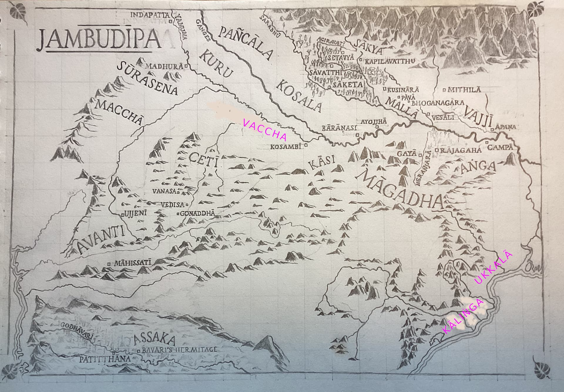
Add Kāliṅga

On the east coast, as it mentioned a few times in the suttas. It’s basically east of Assaka.

You’ve made the hills go down to the sea on this prominence, but on Google maps the hills are somewhat inland, allowing room for the settlement on the coast. I’ve erased these.

Add Ukkalā

This is where the famed merchants came from who fed the Buddha his first meal. Also the mysterious ascetics “Vassa and Bhañña”. The Pali texts don’t make it clear whether the spelling should be Ukkala or Ukkalā, but the dictionary of proper names has Ukkalā, as does Bhikkhu Bodhi, so that’s good enough for me. @brahmali, you currently have Ukkala, just sayin’.

change Vamsa to Vaccha

The clan/region is known in Pali as Vamsa, Vaccha, or Vanga.

  • Vaṅga is the mainstream reading in the Mahasangiti edition, but it can be ruled out, as it is the name of a separate kingdom that is not mentioned in the Pali canon, east of Anga. I think Vanga is vi + anga, “divided Anga”, i.e. portion of Anga split off to the east. It is modern Bangla. It is unlikely that this is what is meant here, because the names are loosely in geographical order from the east (following the sun), and it’s in the wrong spot. Probably in the time of the suttas Vanga was not considered a separate kingdom.
  • Vamsa could be correct, it means “lineage” and can be compared to the Ñātikas, “the family”. But the mainstream Sanskrit term appears to be Vatsa.

This would be Vaccha in Pali; it means “calf”. (If that seems odd, Maccha means “fish”, so. Unless it’s Majja, Majjha, or Macca, all of which are attested variants).

3 Likes

That’s what they all say. Still, Ukkalā it is!

1 Like

In our timeframe, is that a region or a country (i.e. capitals or italics)?

1 Like

It’s a country. Also, my bad, I think it should be Kaliṅga (Kāliṅga is the people, it’s all very confusing!)

1 Like

I‘m assuming all of those are towns? Can‘t find them in the towns and landmarks sections under the SC map. Also, was Moriya by any chance a mining town?

You might want to change this in the section under the SC map, that‘s where I‘m looking up diacritics.

On a related but off-topic note, I‘ve felt a minor urge to write a Jambudipa P&P campaign setting, but gamifying Buddhist doctrine would probably either butcher it in the process or be incredibly boring to play :smile:

Edit: Oh, I was wrong about Koliya, Moriya, and Videha. Could have done some research before asking. (Wasn‘t able to find anything definitive about Uttarapana, though, some clarification about that would still be great.) With Lumbini added, Koliya and Moriya would barely have fit in as towns (2mm height), but putting even one in as a country (5mm height) is impossible with how tightly packed this region is. Same problem with Videha, seeing as there‘s no way I can relocate Vajji to the Himalaya foothills with Kapilavatthu, Lumbini, Kusinara, Pava, and Bhoganagara all being in the way.
I appreciate the scholarly exactitude you‘re aiming for, but we‘ll have to make some concessions to legibility, or the Ganges plain will be an indecipherable snarl of black ink once we‘re done. At this point, if any of those tribes are absolutely essential to have on the map, we‘ll have to get rid of other stuff to make space.

3 Likes

No, sorry. They’re all regions/countries. Videha is a kingdom, which used to be the major power in the region, but which by the time of the Buddha is mostly or wholly swallowed up by the Vajjis. The others are small clan-districts (like Sakya or Kalama).

One reason for representing regions is that we often don’t know the exact location of towns, and also there may be multiple towns identified as in that region, so this helps locate all of them.

Yeah, thanks, I should review that.

Lol.

Actually, my bad, the form in Pali is Aṅguttarāpa, which literally means “Anga north of the water”, i.e. north of the Ganges. It only appears in a couple of places, and the location is pretty clear, so we can leave it out.

Tell you what, I think we can solve a bunch of problems by leaving out Bhoganagara. It’s a fairly minor town, and because it’s mentioned as part of journeys, the location is pretty clear from context. Then we can position Vajji better and include Videha.

No worries, leave them out if need be. If we’re up to it, maybe at some point we could think of doing a second map to detail this area.

3 Likes

pātaligāma ?

1 Like

Yes, I thought of that too. If there’s space, sure. It’s on the south bank of the Ganges, pretty much on a straight line from Rajagaha to Vaishali.

According to Wikipedia, the river we call Neranjara, in modern times meets the Ganges about 25km downstream of Patna. (It seems different on Google maps, but I think it’s a very seasonal flow.) So if we include Pataligama, it’s just to the left of the river confluence.

1 Like


I found this in Ven Nyanamoli’s Life of the Buddha, I’m not sure if it helps in any way ( might be outdated). Add a scale or directionality perhaps?

:dizzy:Lovely work Jonas :dizzy:

2 Likes

Alrighty.

The thought did cross my mind, but I didn‘t want to give you any ideas :smile:

Technically, there is space. But here, too, I‘d ask you to consider carefully, or the map will end up looking more and more like an excel sheet with random squiggles thrown in.
The map we have right now is several times more detailed than any other „literary“ map of the Buddha‘s India I‘ve seen posted on this thread, and we‘re approaching the point where this may turn from an advantage to a problem if we keep adding stuff, at least to the Ganges plain.

Thanks for the resource! There are quite a few differences compared to our map. No idea about the reason, though.

Oh yeah, I completely forgot about the scale indicator. Will add it for the next update! As to directionality, I‘ve never seen a modern map where up wasn‘t north, so I wouldn‘t bother to crowd ours further with redundant info.

3 Likes

Just for reference, here‘s the current version:

  • Most forests are still missing, that‘ll be the next task.
  • Of the four pilgrimage sites, only Sarnath is missing. I‘ll have to re-place Baranasi to fit it in, but wanted to ask for the correct Pali spelling before.
  • Otherwise, I think I made all the changes you asked for, Bhante - except stuff that didn‘t fit, like Bhagga.
  • Don‘t worry about the eraser marks. It‘s getting pretty dirty now, but once it‘s inked and edited, they‘ll be gone.
15 Likes

I’ll leave this to your discretion.

I think our map is quite a bit more accurate. Eg., it has “Vajji and Videha”, but we know Vajji is to the s-w of Videha.

Speaking of which, Videha isn’t quite right in the new map. It doesn’t go down to Apana, which is, rather, part of Anga.

Actually, I notice that the river there is not quite right. You have it going from Apana n-w thru Vajji. In fact it hooks around and arrives at the Himalayas pretty much north of Apana. This river, the Koshi, marks the eastern border of Videha, according to Wikipedia.

The borders of the Videha kingdom were the Sadānirā river in the west, the Kauśikī river in the east, the Gaṅgā river in the south, and the Himālaya mountains in the north.

I’ve marked the new course of the Koshi, and emphasized the Gandak to the west, although that doesn’t need changing. Videha should probably fit above Mithila, emphasizing that it was pretty much squeezed out by Vajji at this point. It’s doubtful they had a sphere of influence to the Ganges. (Conventional wisdom has it that Videha was incorporated into Vajji at this time, but I think it remained as a reduced but independent kingdom.)


In other news, liking the italics!

Just leave it, the site is called “Baranasi” in the text, technically it’s just outside of town but there’s no gain from adding a separate place. You can just star Baranasi.

4 Likes

Just (again) offering bows of gratitude and respect for your patience, effort, and skill creating this beautiful and informative map!
And, of course, to Ven. Sujato.
:pray: :slightly_smiling_face:

8 Likes

The river you erased is marked as the Kamla on the map I‘ve been working off. The river you marked in is identical with the Koshi on my source map (though when looking up Koshi on Wikipedia, it seems to omit that and instead includes the Kamla as tributary), and it‘s already on our Jambudipa map, though I did erase a fair bit of it to make space for your previous suggestion for the placement of Videha, and for some reason I didn‘t draw it all the way north to the Himalayas.
I‘d suggest we keep the Kamla, restore the middle bits of the Koshi after I‘ve put Videha at the Himalayan foothills, and draw it all the way to the north.

And they‘re fun to do! Not sure if we should put in many more regions, the map probably needs some white space… But I‘d be up for a handful, if just for consistency.

2 Likes

Okay, no worries, it just tripped me up.

There seems to be a lot of variability: the rivers are highly seasonal, they flood with the Himalaya melt, and they can change course a lot. But I do think it’s nice to demark the east of Videha.

Some spellings. In some cases I can’t exactly make out if you’re using a diacritical, so I’ll just post it in case. It’s really hard to figure out the right endings on a lot of these!

  • Probably use Gaṅgā rather than Ganges, as we have Pali names everywhere.
  • Vesālī rather than Vesāli
  • Kammāsadamma
  • Maccha
  • Lumbinī
  • Bārāṇasī
  • Malla
1 Like