Is there a nice "literary" map of early Buddhism?

Alright, here’s some detailed feedback, updates, and corrections.

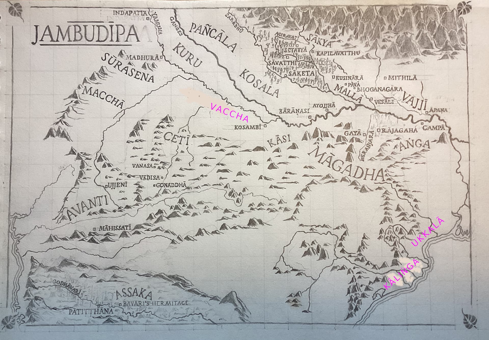
The main thing I’d suggest is to make sure we distinguish the “southern road”. Basically, the southern hills (dakkhinagiri) were a substantial enough obstacle to force the trade route south-west to Avanti. So I would make sure that the hilly region to the north of that (i.e. Cetic, Venasa, Gonaddha, etc.) were nice and gentle, soft round rises rather than peaks.

That aside, here’s a modified map. I’ll explain each point below. I hope you appreciate the subtle artistry I have managed to evoke with my GIMP skills!

forests

I have added forests in green. The main thing was I took a map of contemporary forests in India and superimposed it. It turns out, the forested regions correspond fairly well to the geographical features you’d expect, namely that the forests tend to be in hilly regions less suited for agriculture. Obviously there would have been much more forest, but I think the distribution would have been similar. Anyway this might give you some suggestions as to adding a bit of forest especially in less-populated areas. We can’t get the exact distribution of forest — heck even the Australian Government can’t map its own forests properly—but at least it can convey the sense that there was forest around.

In addition to the superimposed light green, I have added some mid-green forests in the Himalaya region (Nepal was not included in the map of modern forests I used). Basically the Himalayas were skirted with forests in their foothills.

Meanwhile, we should remove most of the forests in the populated areas around Savatthi, etc. Sure, there were forests there, but fewer, and we need space for the names.

south

  • I moved Assaka to the east a little, bearing in mind that Bavari was on the western border of Assaka, which probably covered the central region.
  • I also adjusted the position of Māhissatī. It is located on the river. And since it’s a stop on the way from Patiṭṭhāna to Ujjenī, it would make sense for it to not require a detour to get around the hills.
  • speaking of which, we can probably add a label for the Dakkhiṇāgiri

north-west

  • Indapatta doesn’t appear in the early texts, but Kammāsadamma does. It would be pretty much in the same place or nearby, just north of modern Delhi.
  • Kuru should probably be a bit further north-west
  • Pancala seems to reach the Himalayas in the north, and have the Surasenas on their western border.
  • Speaking of which, we know little of the location of the Surasenas, mostly that their capital is Madhura. It probably makes sense to assume that the hills made the border to their west.
  • Meanwhile, Vamsa has Kosambi as its capital, so could probably move south east a little.
  • I’ve added the Bhaggā lands north of Kosambi (like other additions, if they can fit in!)

east

  • Move Anga a little east, away from Magadha.
  • Add Uttarāpaṇa

middle

  • added Kesaputta (town) (or Kālāmā the land, which might be better)
  • Add Moriyā, Koliyā, and Videha. The former two may not have enough room, but if they do we could put them.
  • Vajjī needs to give the impression of large swathe of land, from the mountains to the river
  • it looks like the hills in n-w Magadha (around Gayā) are too prominent. Check Google Maps, where there are no substantial hills west of Rajagaha (Rajgir). Rather, apart from the steep hills around Rajagaha itself, the n-w of Magadha is pretty flat until you hit the southern hills.
  • Also BTW it’s Magadha not Māgadha (which means “of Magadha”, i.e. Magadhan).

I think that’s about it. Sorry about adding so many changes, my knowledge is getting better over time!

7 Likes

This is really, really lovely.

I haven’t been following the thread super carefully, so if these things have already been discussed and decided, kindly ignore.

Would there be a way for the fonts to have some indication of city/“country”/river? Like rivers in cursive, countries in all caps, and cities in title case? Maybe it doesn’t matter.

And perhaps some deference to the four places of pilgrimage? Maybe with a four pointed star instead of a square?

I’m not seeing Lumbini? And shouldn’t Uruvela be there as the place of enlightenment? Because it’s different from Gayā if my understanding is correct.

6 Likes

I thought that too, maybe put it in if there’s room.

I think it’s too close to Gayā. Maybe we could just say Uruvelā instead of Gayā? But more people are probably familiar with Gayā.

1 Like

This isn’t my project, so I don’t want to come across as being judgemental. However a map without Lumbini would be comically useless for the teaching work I do. But that clearly has to do with the prominence of the four places of pilgrimage in the lives of modern Buddhists than the prominence of those places in the EBTs. After all, even though those four places are critical in the life of the Buddha and Buddhism, he didn’t spend all that much time there, eh?

I actually now regret, or am at least ambivalent about, including Bodhgaya instead of Uruvela on the simplified map I made. If I had to guess, I would think that Gaya’s familiarity over Uruvela would be because people confuse it with Bodh Gaya.

While Gaya (and Gaya Head) are in the EBTs, they are not super important when compared to the place of enlightenment. So if I had to choose between the two, I would always opt for the place of enlightenment. What to call that place would be a more difficult call.

Since one of my goals is always to help people feel more connected to the texts and the life of the Buddha, any map I used would need to contain the four major life events. And would be willing to risk the use of modern names of places when they are unambiguous.

But again, these are just opinions. And I know that the two areas in question are understandably crowded on any map.

This is a lovely and very important map project.

5 Likes

Looks like a rave advert, I love it! :mirror_ball:

Your attention to detail is great, and I don‘t mind the extra work at all, so no worries!
I‘m especially grateful for the forest overlay, and leaving the trees out of crowded places for legibility is certainly for the best.

I think it would be a good idea to vary the font visibly to make it clear this isn‘t a country. What do you say to cursive?

This shouldn‘t be a problem, as the names aren‘t overly long, and you can see how tight they can be packed with Kusinara, Pava, Bhoganagara, and Vesali.

Kalama might be too much, though, with country names being far bigger, and the Ganges plain being crowded as it is. I‘ll try to cram it in somehow, but eh…

You see the problem on your edited version, right? The Vajji letters are right on top of the lettering of the most crowded place on the entire map. I already had to move it for Bhoganagara, and unless I‘m working with different colors as you‘re doing, putting it the way you have would make it completely illegible.

Right now, the differentiation is placement, rotation, and size. The city names are all at a right angle to the page, with a constant height of 2mm, the river names are next to the rivers, going with their direction, and country names are 5mm or bigger, depending on the country‘s size, slanted, and slightly bent. I‘m considering cursive for regions.

Good idea!

The decision would also depend on the main intended use and thrust of the map, i.e. mainly for the upcoming book vs. mainly as a general downloadable and printable resource, and recognizability vs. historical accuracy. I‘m fine with either, but would be more comfortable if you scholars could make the call.

That‘s a strong case for putting it in, then. There‘s enough space, too.

Again, a strong case. Waiting for a decision from Bhante @sujato.

2 Likes

Good to hear. It’s shaping up to be an outstanding work, so it’s worth taking time over.

Sure. Or else italic, which in Garamonds is quite close to cursive anyway.

Oh yes. All you have to do is wave a magic wand and it will all work! :magic_wand:

But yes, I don’t know the solution, but anyway, let’s just bear it in mind.

We should keep the focus on making a printable version for the books.

As to what place to mention here, I don’t have any real opinion. I thought using Gayā was a good compromise, as it is nice and short, and people can make the connection with Bodhgaya. Or else we can use the name found in the suttas for consistency (Uruvelā).

Agreed, there’s no sense in being too purist about it.

Or what about putting Gayā just next to Uruvelā? Then there is still a connection with the name Bodhgaya (or Buddhagaya), and we have more detail from the actual suttas?

You’re probably right, it was by all accounts a small region, probably just the country around Kesaputta.


One little detail I noticed, not that it needs any changes, but we have a rather surprising lack of place names in “west Magadha”, between Rajagaha and Kasi. I think there are a lot of towns mentioned simply as being “in Magadha” for which we don’t know the exact location.

2 Likes

So, Uruvelā and Gayā are different places, aren’t they? I do think having both of those is a good alternative to including Bodhgaya. Because either people will know that Uruvelā is the place of enlightenment, or they will guess that it’s Gayā and be wrong but close. And if you used something like a four pointed star then that would help things too.

“If you’ve a date in Uruvelā they’ll be waiting in Bodh-ga-ya!”

Yes, and for people familiar with the area this works. I know the names of the pañcamahānadī, so it’s obvious to me what the rivers are. And I might know what’s a kingdom vs city. But I feel the current pattern is too subtle, especially since the size of kingdom text varries (as I think it should). And it would also not be possible to put into a key. But this could:

Key:

KINGDOMS/REPUBLICS
𝓇𝒾𝓋𝑒𝓇𝓈
⧠ Cities
✧ Cities for major life events

ETA: Could the Koliya kingdom be included since it’s the Buddha’s clan on the mother’s side? Honestly I know that things are already super crowded in that part of the map, especially once you add Lumbini which is much more important.

You all have really created a thing of beauty.

1 Like

The word “rivers” is illegible to me in this font. It took me a long while to decipher what is meant (and probably that was even shortened by the previous discussion, so there was an idea what to expect).


I haven’t commented on the project so far, but I am really overwhelmed by it! So wonderful!

2 Likes

That could work. As per @Snowbird‘s advice, use it for rivers as well? That way, geographic features would be in italics and human-made features in regular capitals.

Sure. Is just to the south OK?

Could it be a problem with your browser? For me it‘s just a clean approximation of handwriting without the connecting lines, perfectly legible.

Thank you! :heart:

2 Likes

For me too. I mean, it looks like handwriting. But my eyes being not 100% functional it’s hard to decipher for me, especially in a small font like this.

See a screenshot:

Screenshot from 2023-02-06 09-53-32

For me, the “r” and “v” are hard to identify. The “i” is clear (thanks to the dot). And the last two letters “rs” could almost make a “w” together, but not exactly.

It’s probably that the thinner parts of the lines are a little too subtle for my eyes. Maybe a font where there is no variation in thickness of lines would be better.

1 Like

Yeah, I find that hard to read as well. This is what my browser displays:

image

As Bhante @sujato suggested, I‘m inclined to use Garamond italics (scroll down on this page to see an example). How would you rate it for legibility?

2 Likes

Wow! Which browser do you use? For me, both Firefox and Chrome show what I posted here. What you show would be completely legible for me. It doesn’t have the irregularities in line thickness.

Looks much better than what I see here. Thank you!

1 Like

It‘s Firefox for iOS. I‘m assuming the difference is down to custom configurations on your part or mine, system-wide settings and/or font availability.

Glad we could clear that up! Making a map people can‘t decipher would be somewhat pointless. :sweat_smile: If you have any other problems with legibility, please don‘t hesitate to point them out.

2 Likes

So it seems my eyes aren’t quite that bad, after all; rather my browser is … :grin: Or whatever is the responsible factor. My OS is Ubuntu, so there may well be different fonts available, compared to iOS.

1 Like

Anyway it’s just an example, but I was interested in the display issues so I checked it out.

So Unicode has a bunch of substitute characters intended for different purposes, some of which may be cursive or whatever, even if they are in a sans or serif font. There are online converters for them so you can hack around with appearance even in text-only environments; say for twitter user handles. It can get a bit extreme.

:stuck_out_tongue_closed_eyes:ඏ 𝐟Aηςч 𝕊Ć𝒽ϻάN𝐂y 千ⓄŇt𝐬 𝒶𝐫€ 𝐟υᑎ! :chess_pawn::tiger:

Problem is, since they are not the actual characters they appear to be, they are a nightmare for accessibility. In this case, 𝓇𝒾𝓋𝑒𝓇𝓈 is made of mathematical script characters, which on Ubuntu display with the fallback font of Free Serif. It’s an extremely high contrast cursive intended for display sizes. It’d look nice on a poster!

yes, Bodhgaya is 20km south of Gaya.

sounds good, yes.

2 Likes

Jonas, a couple more changes if you don’t mind! I have added these to the original image, so they are in addition to the last set of changes.

Add Kāliṅga

On the east coast, as it mentioned a few times in the suttas. It’s basically east of Assaka.

You’ve made the hills go down to the sea on this prominence, but on Google maps the hills are somewhat inland, allowing room for the settlement on the coast. I’ve erased these.

Add Ukkalā

This is where the famed merchants came from who fed the Buddha his first meal. Also the mysterious ascetics “Vassa and Bhañña”. The Pali texts don’t make it clear whether the spelling should be Ukkala or Ukkalā, but the dictionary of proper names has Ukkalā, as does Bhikkhu Bodhi, so that’s good enough for me. @brahmali, you currently have Ukkala, just sayin’.

change Vamsa to Vaccha

The clan/region is known in Pali as Vamsa, Vaccha, or Vanga.

  • Vaṅga is the mainstream reading in the Mahasangiti edition, but it can be ruled out, as it is the name of a separate kingdom that is not mentioned in the Pali canon, east of Anga. I think Vanga is vi + anga, “divided Anga”, i.e. portion of Anga split off to the east. It is modern Bangla. It is unlikely that this is what is meant here, because the names are loosely in geographical order from the east (following the sun), and it’s in the wrong spot. Probably in the time of the suttas Vanga was not considered a separate kingdom.
  • Vamsa could be correct, it means “lineage” and can be compared to the Ñātikas, “the family”. But the mainstream Sanskrit term appears to be Vatsa.

This would be Vaccha in Pali; it means “calf”. (If that seems odd, Maccha means “fish”, so. Unless it’s Majja, Majjha, or Macca, all of which are attested variants).

3 Likes

That’s what they all say. Still, Ukkalā it is!

1 Like

In our timeframe, is that a region or a country (i.e. capitals or italics)?

1 Like

It’s a country. Also, my bad, I think it should be Kaliṅga (Kāliṅga is the people, it’s all very confusing!)

1 Like

I‘m assuming all of those are towns? Can‘t find them in the towns and landmarks sections under the SC map. Also, was Moriya by any chance a mining town?

You might want to change this in the section under the SC map, that‘s where I‘m looking up diacritics.

On a related but off-topic note, I‘ve felt a minor urge to write a Jambudipa P&P campaign setting, but gamifying Buddhist doctrine would probably either butcher it in the process or be incredibly boring to play :smile:

Edit: Oh, I was wrong about Koliya, Moriya, and Videha. Could have done some research before asking. (Wasn‘t able to find anything definitive about Uttarapana, though, some clarification about that would still be great.) With Lumbini added, Koliya and Moriya would barely have fit in as towns (2mm height), but putting even one in as a country (5mm height) is impossible with how tightly packed this region is. Same problem with Videha, seeing as there‘s no way I can relocate Vajji to the Himalaya foothills with Kapilavatthu, Lumbini, Kusinara, Pava, and Bhoganagara all being in the way.
I appreciate the scholarly exactitude you‘re aiming for, but we‘ll have to make some concessions to legibility, or the Ganges plain will be an indecipherable snarl of black ink once we‘re done. At this point, if any of those tribes are absolutely essential to have on the map, we‘ll have to get rid of other stuff to make space.

3 Likes